With just a single click, you can explore any corner of the world from the comfort of your home. Apart from this, there have been numerous amazing Google Earth discoveries.
But it’s not just a neat toy; some extraordinary things have been discovered with its one-click access to satellite imagery.
1. The largest natural bridge on Earth is located in China and was unknown to the rest of the world until it was discovered via Google Earth.
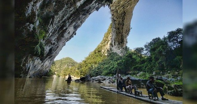
Jay H. Wilbur, an arch enthusiast, was going through Google Earth when he happened upon something in China that looked like a giant natural bridge. Wilbur is a founding member of the Natural Arch and Bridge Society (NABS), and his expert eyes immediately recognized the structure as a natural bridge. Moreover, there was a Panoramio image by Ivanytng, a Chinese photographer, that confirmed the arch enthusiast’s speculation.
In 2010, a seven-person team of the NABS visited the area where the structure was located and took measurements. The measurements amazed them. The bridge has a span of 400 ± 15 feet with a height of more than 200 feet. This clearly made the newly discovered structure the largest natural bridge on Earth. Prior to this, the largest bridge was the Landscape Arch in Arches National Park, United States, with a span of just 290 feet. This amazing creation of nature was likely to have remained hidden if it was not for Google Earth.
2. There is a Star of David on the rooftop of Iran’s largest airport that was emblazoned more than 30 years ago.
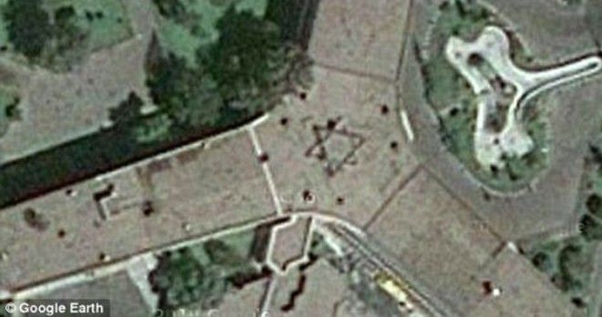
In December 2010, there was outrage among Iranian officials as the result of a discovery of a Zionist symbol. The Star of David was etched on the rooftop of Iran’s largest airport. Apparently, the discovery was made via Google Earth. Officials in Iran called for the immediate removal of the Zionist community symbol as soon as they learned about it.
Even though it has been more than 30 years since Iran and Israel broke ties, the airport building was constructed by Israeli engineers prior to the 1979 Islamic Revolution. That is presumed to be the explanation for the presence of the symbol.
3. The lost mountain of Mabu in Mozambique, which holds the largest medium-altitude rainforest in southern Africa, was first discovered by scientists using Google Earth.
It’s surprising that there are still places on Earth that are untouched by any civilization. One such place lies deep within the forests of Mozambique. It is a mountain that was discovered by scientists in 2005. Prior to this, only the locals had the knowledge of this mountain.
The mountain was discovered by Julian Bayliss, a biologist at the Kew Royal Botanical Gardens. Bayliss often used Google Earth to uncover new biodiversity hotspots across Africa that were not previously known. Upon the discovery, an international team of 28 scientists, under the leadership of Bayliss, went on their first expedition to the mountain in 2008.
The amazing part about this discovery is that this particular mountain, Mount Mabu, is the home of the largest medium-altitude rainforest in all of the southern part of Africa. Also, the biodiversity is phenomenal. The team of scientists discovered a rare orchid and a parasitic shrub, Helixanthera schizocalyx, that is hairless and grows by attaching itself to plant branches. In all, they collected more than 500 plant specimens for study.
Scientists discovered not only plants but also many new animal and insect species. They found about 200 different species of butterflies. Mount Mabu also houses many endangered birds, with one of them being the vulnerable Swynnerton robin. The Thyolo Alethe, a bird that is endangered elsewhere, is also found all around the forest. In total, 126 bird species were identified on the mountain, with six of them being vulnerable globally. They discovered multiple species that were altogether new to science.
4. A mysterious dome “building” was seen on Antarctica leading to speculations that it may have been created by an ancient civilization.
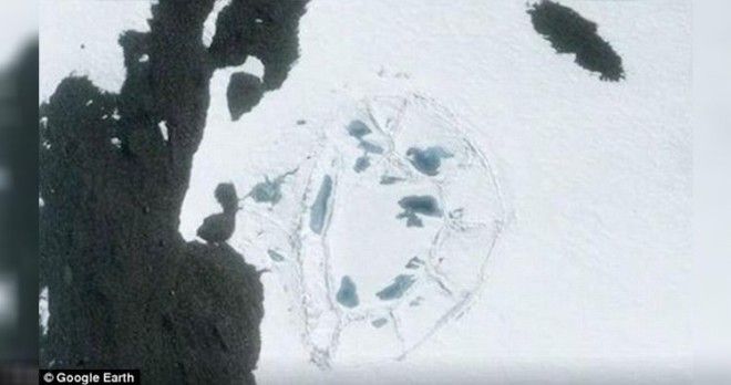
In January 2017, a mysterious oval-shaped structure was seen using Google Earth over Antarctica. It is believed to be spanning across an area of 400 feet. Scientists initially thought the structure to be a sastrugi, a natural phenomenon that is formed by years of pounding by strong cold winds and heavy snowfall. But sastrugis are never known to form an oval shape like the structure seen using Google Earth.
Ashoka Tripathi, an archaeologist with the Department of Archaeology at the University of Calcutta, believes that this structure may have been man-made and could offer evidence of some ancient civilization. Maybe Antarctica was home to an ancient civilization that was wiped from the face of the Earth and we had no evidence of it until now.
This is not the first time when images from the Antarctic have raised speculations on the existence of human civilizations. Earlier, images released by NASA from their ice-mapping mission, IceBridge, showed some pyramid-shaped structures that were clearly not natural formations. Scientists are still working on identifying the source and cause of such structures discovered across Antarctica.
5. A Google Earth user in June 2006 discovered a very detailed 1:500 scale terrain model of a disputed border region between India and China. It is 3,000 × 2,300 feet large and is located near a Chinese military complex.
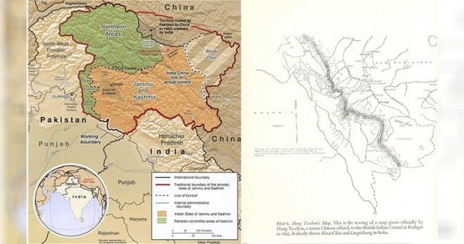
There is a disputed border region between India and China known as Aksai Chin. It is claimed by China as part of Hotan Prefecture of Xinjiang Autonomous Region and also by India as part of the Ladakh region. Both the countries fought a war in 1962 in Aksai Chin and Arunachal Pradesh over the ownership of the area, but in 1993 and 1996, they signed agreements to respect the Line of Actual Control.
In 2006, some Google Earth spotters noticed a man-made structure at a remote location in China that resembled the Aksai Chin. The structure has been built to scale within a large military complex and is incorporated with man-made snow peaks, freezing lakes and snow rifts even though it is in the middle of an arid plain.
When approached by the media, the military did not confirm its knowledge of the structure. They just said that it is not uncommon for militaries to devise simulations of conflict regions for training purposes. Many believe that in spite of the peace dialogues between the two countries, the PLA is still keeping its forces in touch with the conflict zones.
6. A huge range of bones and teeth of mammals were discovered which might have belonged to some of the first mammals to migrate from Asia to Africa.
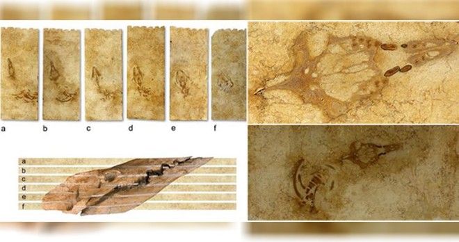
In 2009, masons in Italy were cutting limestone and working on shaping them when they noticed that some slabs looked like cross-sections of a skeleton. These slabs were imported from Egypt. Paleontologists were called upon to confirm their speculation. Giovanni Bianucci, a paleontologist at the University of Pisa, confirmed that the slabs were actually the fossilized remains of a whale that swam in the waters of Egypt some 40 million years ago.
The news traveled to Philip Gingerich, a paleontologist at the University of Michigan. He wanted to visit the original site from where the slab was mined. All he knew was that the slab came from a site near the Egyptian city of Sheikh Fadl. To avoid wasting time, he opened Google Earth and zeroed in on the area some 75 miles east of Sheikh Fadl.
When he visited the area, he found a large quarry. He discovered numerous small bones and teeth. These remains belonged to small mammals that must have lived some 18 to 20 million years ago in the early Miocene Epoch. Moreover, considering the size of the bones and teeth, they were the first small mammal fossils of that age to be discovered in Egypt. Paleontologists believe that they might have been the first small mammals to have migrated from Asia to Africa when the land bridge through the Khasm el Raqaba area between the two continents was formed.
This is a startling discovery for the paleontology world as it might shed some light on how the African wildlife began.
7. A computer programmer accidentally stumbled upon the remnants of an ancient river and the courtyards of a Roman villa while studying a map of his town.
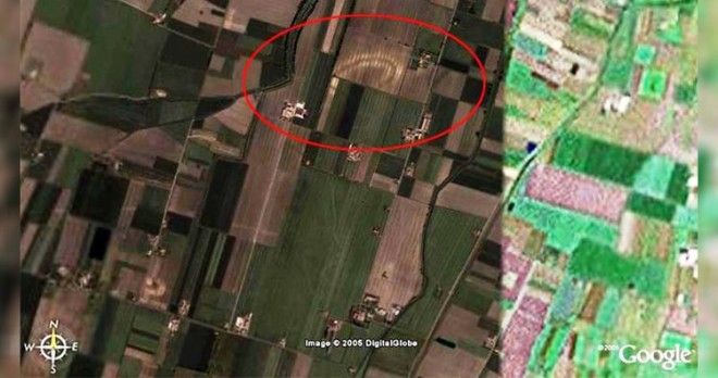
Luca Mori, a computer programmer from Italy, was casually studying the area around his town Sorbolo using Google Earth when he noticed an oval-shaped structure. It appeared to be more than 500 meters long and was quite prominent on the map. When he observed closely, he noticed that it was a curve made by some ancient river. The structure was so prominent because of the difference in moisture absorption between the old water source and the surrounding area.
Also, Mori discovered something else on the map. He saw few unusual shadows that were rectangular in size. He analyzed the image properly and came to the conclusion that the rectangular structures look like a courtyard of some ancient villa. Mori then contacted archaeologists and experts from the National Archaeological Museum of Parma (NAMP). They confirmed Mori’s speculation that it was actually the remains of an ancient Roman villa.
An archaeologist at the NAMP said that they have also found remnants of other villas while excavating at Cannetolo di Fontanellato. They are trying to find out if these two are cases are related.
8. Google Earth was responsible for the discovery of two 2 million years old skeletons that proved the existence of another species of human ancestors.
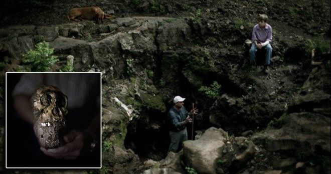
Google Earth was responsible for the discovery of a new hominid fossil at the Cradle of Humankind World Heritage Site in South Africa. When it comes to palaeoanthropological discoveries, this is one of the most significant discoveries in recent times.
The discovery brought into limelight two partial hominid skeletons, a woman and a boy, dating to between 1.78 and 1.95 million years. Professor Lee Berger of South Africa’s Witwatersrand University has been resorting to Google Earth to identify previously unknown cave sites since 2007. He had already discovered around 600 caves and fossil deposits at the Cradle of Humankind World Heritage Site and chanced upon these skeletons when his son stumbled upon them while playing.
The discovery of the two skeletons was notable because they might provide a clue as to the ancestry line of humans. Scientists believe that these skeletons belonged to an unclassified species of advanced Australopithecus with similarities to Homo. Based on their unique and primitive anatomy, scientists believe that they may have been the immediate predecessor to Home sapiens or a close relative/branch to Homo sapiens that did not evolve into modern humans. This new hominid species has been named Australopithecus sediba.
9. An Italian researcher landed upon the most well-preserved crater in the world using satellite imagery.
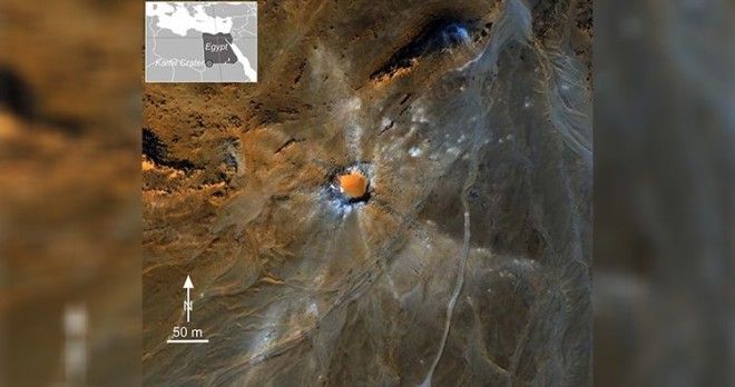
A crater created by a meteorite impact was noticed via Google Earth images in 2008 by Vincenzo de Michele, a former curator of the Civico Museo di Storia Naturale, Italy. The amazing part about this discovery is that the meteor is quite well-preserved as compared to the other craters here on Earth. Some meteor curators have confirmed seeing this crater in satellite images taken in 1972.
The rim of the crater is about three meters in height, and it is surrounded by light-colored spokes of material that must have blasted out of the ground during the impact. Such fresh spoked-craters are not common on Earth and are most often found on Mars or the moon. This is because Mars and the moon have quite a thin atmosphere that limits the number of environmental processes that leads to erosion of the craters. It’s a wonder how this specific crater on Earth has been so well-preserved.
Also, since the crater is so well preserved, it will help scientists gather information on impacts caused by small-scale meteorites. They will also get to assess the hazards caused by such small-scale meteorites. This is a big opportunity as most of the small meteorites burn up as soon as they enter the atmosphere and do not even get the chance to reach the ground.
10. A massive 853-foot ancient tidal fish trap was found that was built in the 11th century.
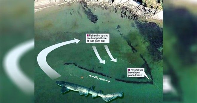
An 853-foot-long fish trap was discovered off the British coast via aerial photographs that were taken by Google Earth. Scientists believe that the trap must have been built some 1,000 years ago. The strange underwater shape was first noticed by a plane flying over it. Archaeologists were then notified and they took a closer look with the help of Google Earth.
The trap, which is V-shaped, provided scientists with valuable insights on how people from the medieval ages survived on hunting and fishing. Dr. Ziggy Otto, a marine environment lecturer at Pembrokeshire College, was part of the team to have visited the fish trap and he says, “It would have taken a number of fishermen to work on a structure of this size. The fish were herded into the trap, and when the tide went out they would be scooped out with nets.”
Over centuries, the structure has metamorphosed from a man-made fish trap to a fully sustainable, natural reef.

