See, with a story you’re getting one point of view. It’s like history. It is written by the winners, literally stating HIS-STORY. The idea behind it is that people tell stories of things that have happened and they are documented as THE story. However, there are often two sides to every story, not just one.
You need to know the truth. The best way is to see for yourself, right? Of course. It is how we determine the truth over a lie. This leads us to opening Pandora’s box at times. The movie Se7en should have told us that boxes were bad to open, as the mystery is often better than the actual thing. Yet there are times things are insanely real.
Sometimes it’s not just regular people who are baffled by things, but scientists as well. One of the most common places this happens is from Google Earth. The website captures images of Earth off and on during the year. There have been some very weird things discovered here, and scientists did not know what to think. We’re going to break down a list of fifteen such images that have come across Google Earth, and why scientists were baffled by them. Enjoy.
15. The Mysterious Desert Pattern That Surprised Us All
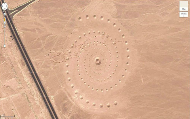
When you see patterns pop up in the desert, you start to wonder how they got there. Google Earth has been around for some time, and satellites have been peaking in on the Earth far longer than Google has. That said, scientists and other organizations have come across mysterious things in the past. It was much easier to cover them up before, but with Google Earth around, things became a lot tougher. This crop circle came to be inside the Red Sea Governorate in Egypt.
Few could explain it, but it was clearly manmade. Was it there for a long time or did it just come about? It took people for a loop when it first came about. Luckily, the issue was eventually put to rest. The group D.A.S.T came out to claim they were responsible for what everyone was seeing. It is a land-art project they are calling “Desert Breath.” Well, at least we know it wasn’t aliens this time. THIS TIME.
14. Canada’s Badlands Guardian

When this was captured by Google Earth, it took a lot of people by storm. It hit the internet and many went crazy with the thought that something truly spectacular was happening. The picture was captured in Walsh, Alberta. This is of course inside Canada, and that made it even more intriguing. Canada is known for some truly amazing sights, but this was kind of weird for them. You can see how everything is carved out into the land like normal. However, in all of the normal looking land, you can see a face pretty easily.
Some thought it was an Indian Chief who was looking out for the people, which gave it the name “The Badlands Guardian” from many. Obviously before the English arrived, and even before the Vikings did years prior, all of North America was part of Native American land. While it is likely no one actually carved this out, it is quite interesting the face is shaped similar to a Native American.
Many scientists claim this was simply the way the Earth built itself out. The problem is, no one can actually understand how the face came about or how it looks so much like a Native American. This has led to many thinking it is just a coincidence, and that is truly the only answer experts have.
13. A Pyramid In The Antarctic?
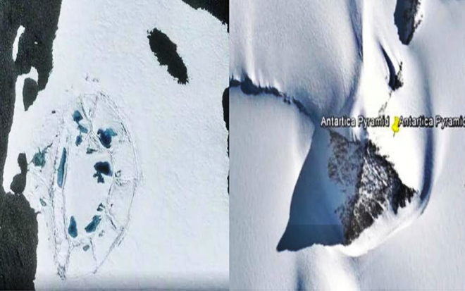
It may be sad to say this, but we may need to change climate change for a second. While debating over why it’s happening so badly now can come at another time, we can assure you that this image could have only happened due to it. Google Earth came across something amazing in 2016. A pyramid in Antarctica. The theory among many is that there were cities made here centuries ago that have basically been covered by snow and ice, far too deep for anyone to see or know of them.
When this was seen, scientists were quick to dispute it. Claiming that it could not be a pyramid but rather natural formations of the Earth. Meanwhile other scientists and historians were quick to mention that Antarctica was not always a frozen wasteland. It was similar to New Zealand. Remember Pangaea? When the land tore apart, it took millions of years to form into what we see today. That said, it is entirely possible for a manmade structure to have existed here and frozen in time.
12. Caledonian Heart

This image comes to us from New Caledonia, and it shows a heart. There have been many hearts that Google Earth has come across in its time, though. What makes this one so special then? Many other formations in the land are manmade. Whether they are planted trees, places dug up, or what have you. In this case, the land actually crafted this on its own….without human intervention.
This makes it an interesting find for scientists. You cannot really explain it if you’re a scientist. All you can do is say that it’s a heart that was formed from the land. However, this shape is not what a real heart looks like anyway. Regardless, it is how we see the heart that counts, right? Scientists have difficulty explaining what nature does on its own. It makes sense. However, it is quite interesting that something like this could be formed in the land.
11. The Giant Pentagram From Hell
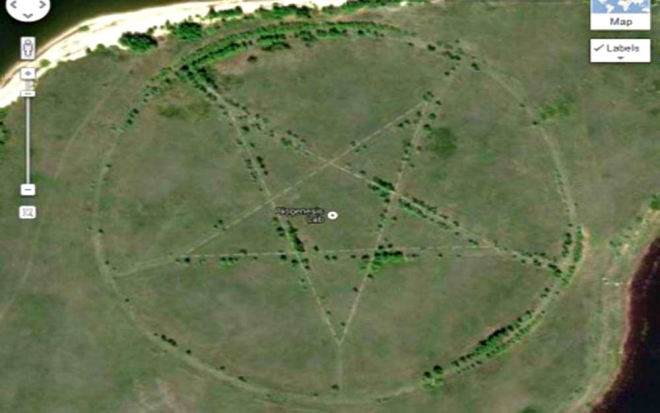
When you see this, you start to consider your life choices and what brought you here. Maybe you consider the idea of building a laser, putting it up in space, and beaming down a way to destroy this thing. Since not all of us can be Batman, we’re looking at this image and wondering how it was done. Basically, it was built a few ways. Firstly, human beings shaped out the field. This is how it was able to look like this.
Over time, things can go back to what they once were. However, in order for it to be visible from space, at least to Google Earth from a high position, it needs to be big. It needs to be VERY big. So the people had to make sure it was large, and large enough that it would be able to stay if human care is removed. Human care has sort of been removed, which has allowed it to fill in here and there. However, it looks as if it would remain visible for quite some time even without maintenance from people. Scientists see this image and they realize that it can stay together, but they do not know why it was made ultimately.
10. The Broken Face
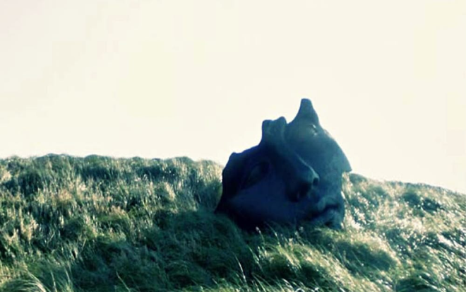
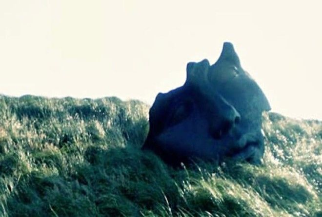
History tells us that kingdoms fall, and thus, the monarchy along with it. No statue will remain of them and kingdoms will never be the same again. This is known throughout all portions of history. When Alexander the Great dominated most of the world that was known at the time, he made sure to continue traditions kingdoms had, but the monarchy there was sent out most of the time. Some took over and took all things away, punishing the people. It ultimately depended on the ruler. In the case of the family this statue belonged to, things did not go well.
Usually when statues come down, they’re completely destroyed. The people demolish them and get rid of the remains so that no man or woman will know of their existence. While this statue could have belonged to a monarch, it could have also simply belong to someone who did something nice for a town. The real question for scientists and historians is where this was, to know who it might have been. Either way, it’s insanely creepy!
9. Saudi Volcano Or Gates Of Hell?

When looking at this, your first instinct is to rightfully wonder….what am I looking at? What you’re seeing is an area with an active volcano in Saudi Arabia. What is the significance? This image shows gates of sorts, which are not marked by us or Google Earth. They actually exist here. Scientists looked it over with baffled eyes, as they had no actual understanding of how it could have been. These “gates”, are made of stone it appears.
While it was originally ruled to be a formation made by the Earth at first glance, another scientist familiar with the region looked into it to find that they were stone built. They are the oldest manmade structures in the region, in fact. Yet there was no significant purpose made for them apparently. Though it could be assumed the people of the time knew what was going on. In the past, there have been religious types who would do crazy things to cater to their God or Gods. Could this be something done for that purpose? We may never know.
8. The Monument In Petra
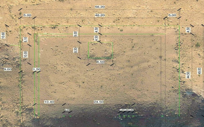
In Jordan, there is Petra, an area where little is seen. Scientists were baffled over the region for years, so they actually called upon the help of Google Earth among others. The idea was to help them find things in the area. What they uncovered is a Petran monument. The highlighted picture above shows the Google Earth image with areas of the ground pointing to parts that need to be looked at. The middle spot with the box is where the big prize is located.
Petra dates back to 4th Century BCE. So to say it is old would be an understatement. A lot can be said about the time, as the historians and archaeologists had uncovered just about all one could really find on the area. That was why this came as a surprise, as it had been studied since the 19th century. It was baffling when first brought up, as the monument had been “hiding in plain sight” according to scientists.
7. Chinese Patterns That Make No Sense
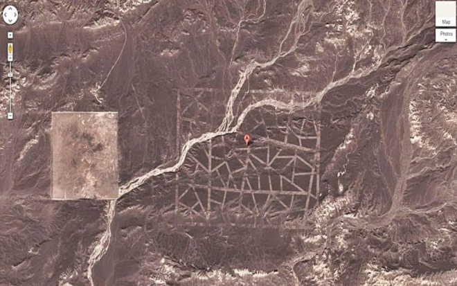
In China there is a place where patterns are able to be seen from space….well, for Google Earth at least. What makes this so interesting and compelling is that none of this has to do with Chinese symbols or any form of language from the region. This is just a pattern that really has nothing to do with anything notable, but it stands out. There’s really no reason for it, which is what baffles people the most it seems.
Usually when people make things, or patterns are seen, there is a reason. This clearly looks manmade, so we know the Earth did not have anything to do with it. Though scientists have concluded that parts of it very well could have been natural, but the entirety could not have been. What you’re seeing here is not scary and it is not shocking. It’s just weird, which might be the most baffling thing in the end.
6. When Google Earth Captures Something Terrifying…Kinda
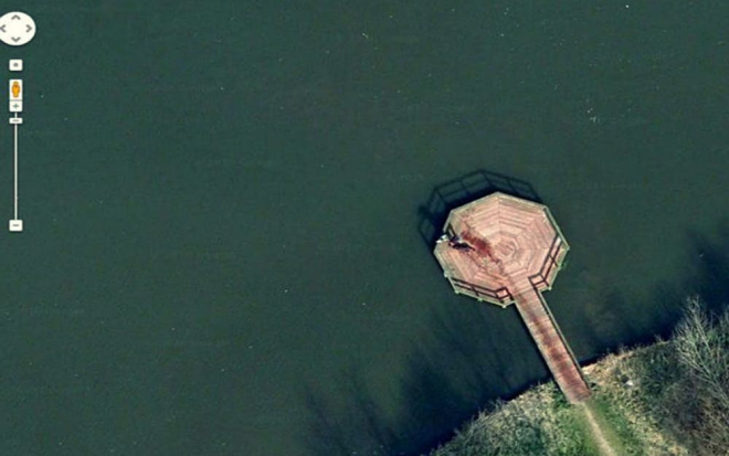
In this image, you see what could not be totally made out by Google Earth, but it looks ominous just the same. Their images are often blurred a bit when it comes to direct photos of things on the ground versus the high point in the air. This image began to get a lot of traction around the internet. It was hard to determine. The wood looked red, which
Later on, evidence would come into play and it would be found to have been a man with a wet dog. The image had an issue. In that due to the pixels being a bit messed up, the color did not catch red. Rather, it caught a lighter brown color that this particular wood somehow showed as red on the Google Earth image. While baffling at first, things ended up working out where everything caught up to us from an information standpoint.
5. Red Lips Of Sudan
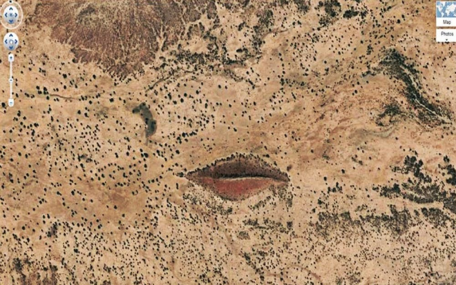
When this image was first seen by Google Earth, it went viral mainly because of the beauty of seeing this from such a distance in such beautiful splendor. Sudan is notable for being mostly all desert with no real give in the land. It’s harsh, hot, and like hell on Earth in multiple ways. No one wants to get caught out there, and for obvious reasons. That was why what is now being dubbed “the red lips of Sudan” was such a pleasant surprise for people to come across. While you can only tell from a high distance that you’re seeing red lips, the entire thing is quite large on the ground and looks as you might assume.
They are about a half-mile long and made from rocky outcrops in the Earth. When scientists first came across it, this was quite a weird thing to see. The Earth had not been stained, and there was no real bloodshed here that would have stood the test of the time. While they knew about the formation before Google Earth, the idea that it is still a bit hard to explain how it came to be has become interesting for many.
4. Potassium Pools That Will Shock The Eyes
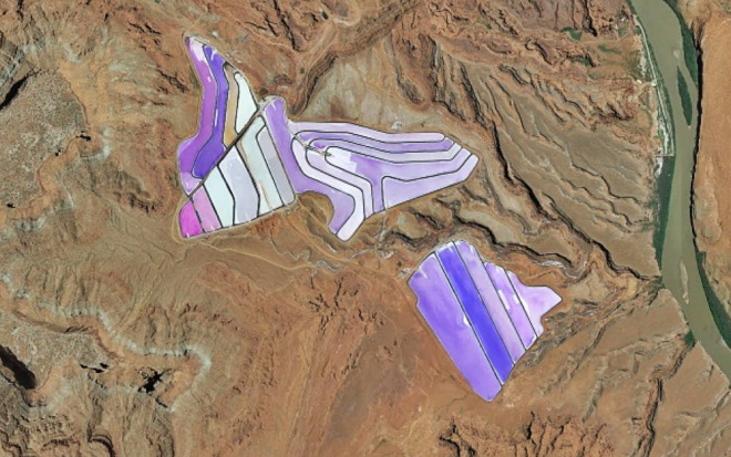
There is one thing nature usually tells us. The sky is blue, grass is green, and water is wet. These are facts that we’ve come to trust. However, even those facts have amending factors to them. That is why lakes like what you see above make no sense to believe are real. They look like a child colored them in, right? However, this is an undoctored image of what are known as Potassium Pools. This is an area inside the United States. How in the Google Earth did this come to be?
Its name is pretty much what explains it. Scientists were baffled by these for a long time. However, they were able to determine that when oceans covered most of the Earth, the water would eventually fall out of the way in favor of land. Potassium deposits were found in the areas that were once under water. Whatever potassium remained would form crystals and leave the color of the pool we see now. Some would be buried under the Earth’s crust due to tectonic plate movement. This would result in mines that have similar looks. It’s still all really weird despite knowing the cause!
3. Just Your Normal Plane Crash…
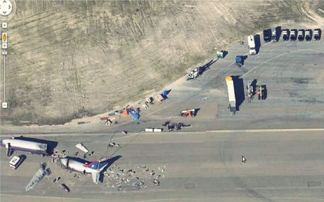
It seems that Google Earth is gifted when it comes to picking things up at the right point. It appears that they have caught a plane crash on their Google Earth view. What is lost on this is the amount of other wrecked material there. You can also see multiple police cars and even an 18-wheeler, because you always need those at the site of a plane crash. It’s in all the movies guys, keep up.
It can be noticed that the plane crash ultimately led to a break in the half of it. Little tidbit of knowledge here, most experts say in a plane crash to be in the back. There’s a number of reasons, but apparently you can somehow make it out better. It appears that this road is long, similar to that of a place the plan actually could have landed safely. Which in the end is what most likely baffled scientists. When you have a huge road, should you not land with the normal landing gear? If you’re coming in too hot, circling around is still possible. Most pilots are prepared for times like these. Just ask Sully, he can tell you. Or Tom Hanks, he’s the next best thing.
2. There’s A Monster In New Zealand

A disturbing image was captured by Google Earth that shook everyone to their core. We’ve all heard the rumors of a monster in some area of the world. Real life ones have even been uncovered over the years. Especially deep in the ocean. However, this image would make anyone fear for their life. You can clearly make out a line, shadowy looking, in the water. It’s inside the water of Okie Bay in New Zealand, and one would wonder how it got so close without others seeing it.
According to debunk specialists, they determined that a boat left behind this track. As you can see, many boats are in the area, so it made sense to assume. Here’s the issue. This is an extremely long line and no boat would leave one that significant with even the curve at the top still being there. Even with perfect timing by a camera, most of that would have died off. That makes many still wonder, which could be why this has not been officially debunked yet. Scientists are still baffled by the mere idea. They too thought it was a boat, but also speculate there could not be a clear line like this with a boat alone. So what else caused it?
1. The Black Hole That Google Earth Cannot See Into

What may shock you is that Google Earth cannot see everywhere in the world. People often assume they should be able to, and they do a great job most of the time at finding whatever you can think of. The ultimate issue is that some parts are just unable to work. Google has tried to better its technology when issues like this come up. Which helps solve the issue. Yet no matter what they do, there is one area that seems to cause them immense issues. The Kantega in the Himalayas. This tremendous area of the mountains reaches a total of 22,251 feet in altitude.
What is so interesting about it, is that you can see a huge black spot where the peak is, as well as a significant portion under it. The black spot has baffled a lot of people. This is mainly because people have climbed this area in the past and they have noted how it’s off to itself in plain view. It makes no sense that Google Earth cannot see it. Some assume it might be due to the time of year. But every single day of the year, Google cannot see into it. This has sparked a lot of conversations about UFOs being held here. The thing is, no major government would use this and even if they could….would the tech geniuses at Google be stopped? Perhaps they were paid off to keep a secret no one is supposed to know. Hmmmm….
